|
|

|
|
Agriculture: Supporting sustainable agriculture and combating desertificationThe Harmonized World Soil Database (HWSD) as a First Step Towards a Global Soil Information SystemRecognizing the critical importance of soil observations to GEOSS, the global soil survey community is uniting to contribute to GEO (Task DA-09-03: Global Data Sets, sub-task Global Soil Data). This sub-task is co-led by a group of soil institutions, including the European Commission Joint Research Centre, and the International Soil Reference and Information Centre (ISRIC)-World Soil Information in The Netherlands is the point of contact (vincent.vanEngelen@wur.nl). The purpose of this effort is to support the development of a global soil information system that builds upon the work of ongoing and completed projects. The system will incorporate data from global, regional, and national soil data projects into a coherent system using a common dictionary – to support implementation of major multilateral environmental agreements (e.g., United Nations Framework Convention on Climate Change, United Nations Convention to Combat Desertification, and Convention of Biological Diversity) and provide harmonized and policy-relevant information to users at the global, regional, and national level. The freely accessible system will deliver web-based services on soil information. The Food and Agriculture Organization of the United Nations (FAO) and the International Institute for Applied Systems Analysis (IIASA) have taken the first step towards a fully operational global soil information system. They took the initiative of combining the recently collected volumes of regional and national updates of soil information with the information already contained within the 1:5 M scale digital FAO-United Nations Educational, Scientific and Cultural Organization (UNESCO) Digital Soil Map of the World (DSWM; FAO/UNESCO 1995, 2003), to create a new comprehensive Harmonized World Soil Database (HWSD). HWSD uses four distinct sources of data (see Figure 1):
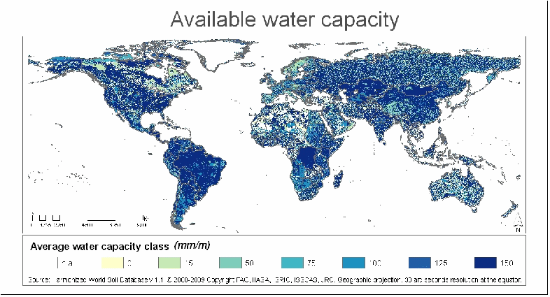
A number of soil qualities can be derived from this new database. Examples include the organic carbon pool and the soil water holding capacity (see Figure 2). The HWSD constitutes improvements for about 60% of the land area as compared to the FAO/UNESCO Soil Map of the World. The http://www.globalsoilmap.net/ (Sanchez, et al., 2009) digital soil mapping project that will provide the global information system of the future is in its second year, and completion for Sub-Saharan Africa, let alone the World, is some time off. Readily available databases such as those present in Australia, Canada and the United States of America can easily be transformed in a similar 30 arc sec product. In other regions, such as West Africa and South Asia many countries have the soil maps and soil profile databases required to contribute to an expanded HWSD. Ongoing discussions in the framework of the Group on Earth Observations (GEO) that aim towards the development of a Global Soil Information System (GLOSIS)—a "system of systems of soil data and information" as part of the Global Earth Observation System of Systems (GEOSS)—already have identified a possible improved HWSD as an intermediate product to be completed in the short term, prior to the final release of the future Global Soil Map (GEO 2009-2011 Work plan, 2009). For more information visit http://eusoils.jrc.ec.europa.eu/esdb_archive/Soil_Data/Global.htm. Contact: Luca Montanarella, European Commission (luca.montanarella@jrc.ec.europa.eu). |
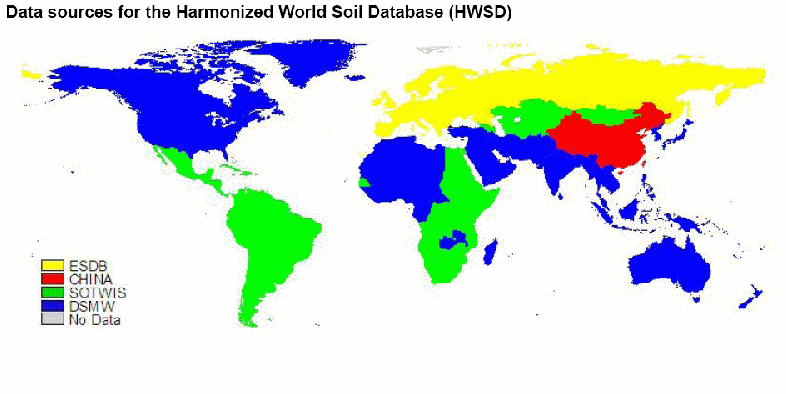
Figure 1. Sources of HWSD
Figure 2. Soil Moisture Holding Capacity Derived from Soil Properties in HWSD |