|
|

|
|
Agriculture: Supporting sustainable agriculture and combating desertificationGeo-wiki.org - Crowdsourcing to improve Landcover ValidationImproving the quality of spatial information: With an ever increasing dependence on spatial information, and an increasing importance placed on results derived from that information, it becomes crucial to better harmonize and understand the quality of this expanding volume of data. New opportunities exist to collect additional spatial information via the Internet that were non-existent until just a few years ago. Additionally, many international, intergovernmental protocols and conventions rely on this information (e.g. the Kyoto Protocol, the Convention on Biological Diversity, the Convention to Combat Desertification; and others). However, much of the spatial data used to support these important initiatives is conflicting or contains limited validation. New efforts are thus required to improve the quality of spatial information. What we do: Currently in geo-wiki.org, volunteers have the ability to view both cropland and forest Disagreement Maps that were derived from three recent global land cover datasets: GLC-2000, MODIS and GlobCover. Disagreement Maps guide the volunteers to areas of the globe with the highest levels of disagreement – prioritizing the disagreement hotspots in a global cropland/forest Disagreement Map (Fig. 1). With the help of Google Earth, the next step is to select and visualize available high resolution images as well as to upload or view geo-tagged field pictures (e.g., from Panoramio.com, Confluence.org, or from research projects such as the Global Monitoring for Food security Project (GMFS)), and determine which land cover type is found on the ground (Fig. 2). Volunteers are then asked to decide if the land cover products correctly capture what they see or know to exist on the ground. In addition, it is possible to recommend a new land cover class (i.e. select from a list of possible land cover types, and upload available photos to support the decision). All information entered by volunteers is recorded in a publically available spatial database. This validation database contains a record of the agreement among the datasets, and can be used in the future to create an improved hybrid dataset. Who we are:
Benefits for S&T communities: The Geo-wiki provides direct benefit to the S&T community via:
Added value of GEOSS: Since global land cover datasets contain large areas of disagreement (e.g. a total area of 404 million hectares is identified as croplands in GlobCover but as non-croplands in MODIS), it is beneficial to involve a wider community to validate global land cover datasets and to provide essential information which can help to improve current global land cover. The traditional approaches of data collection and accuracy assessment are still valid and necessary, but can be complemented by such validation exercises. Sustained benefits for S&T communities: The International Institute for Applied Systems Analysis, is committed in the next years to maintain geo-wiki.org. Information collected through this tool is continuously recorded in a publicly available spatial database. This application complements previous validation exercises of these products (such as field validation by trained experts) and current efforts of the Earth Observation community to develop an improved global land cover validation database. More importantly, it is intended to lead to a hybrid consolidated land cover map, by combining different maps through geo-statistical methods, incorporating the additional land cover information retrieved by the geo-wiki tool. For more information visit geo-wiki.org. Contact: Ian McCallan, IIASA (mccallum@iiasa.ac.at). |
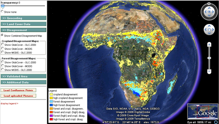
Figure 1. Results of global land cover disagreement in both cropland and forest areas, based on an analysis of three existing land cover products: GLC-2000, MODIS and GlobCover.
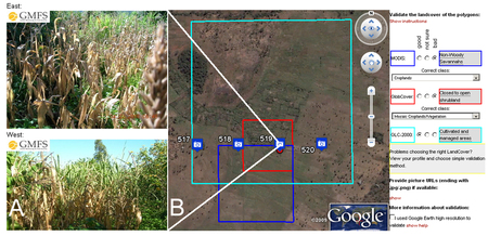
Figure 2. Geo-tagged photos uploaded in geo-wiki.org (A) confirming the actual land cover seen in Google Earth high resolution images (B). Using the high resolution images available in Google Earth, in combination with available photos, a volunteer can correct existing land cover products. |