|
|

|
|
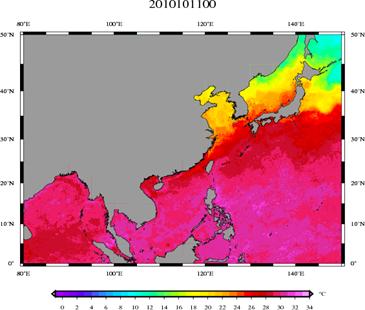
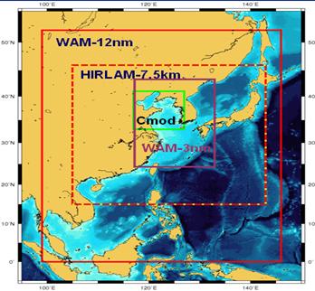
Climate: Understanding, assessing, predicting, mitigating, and adapting to climate variability and changeCapacity Building of Operational Oceanography and Climate AdaptationRationalOceans and seas play a major role in the climate system both acting as climate regulators. They also are particularly sensitive to climate variations. Marine strategies for adapting to climate change have been made for many regional seas, in order to reach a safe, sustainable and efficient marine economy. Operational oceanography, by assimilating earth observations into models and forecasting the future status of the ocean and seas, is an indispensable tool in realising these adaptation strategies. This example demonstrates a global scale capacity building effort on operational oceanography and its possible application for adaptation measures in developing countries. Through cooperation among European Union (EU), China and South Korea partners under GEOSS, high resolution European weather-ocean-wave forecasting systems have been implemented for Northwest Pacific Coastal/Shelf seas and demonstrated in an operational mode. This has led to several new projects on operational oceanography in China and South Korea. Similar efforts are expected to be taken for Africa and Latin America by partners from EU, the United States, and relevant developing countries. The operational ocean monitoring and forecasting capacity enables developing countries better disaster prevention and to take more efficient climate adaptation measures in coastal engineering and integrated management. The implementation of this example is within GEO Task CB-09-03d “Building Capacity for Operational Oceanography,” which aims to enhance sharing ocean data and best-practices in GEO and stimulating global cooperation on operational oceanography, especially between developed and developing countries. Added Value of GEOSS for the S&T CommunitiesThis example is based on a global network for capacity building of operational oceanography, including advanced centres from both developed and developing countries. This example demonstrates a close GEOSS cooperation on a global scale and how to improve ocean data sharing through operating collaborative projects. Significant GEOSS Science and Technology (S&T) issues such as: multi-sensor satellite products; in-situ observations; innovative ocean/weather modelling and assimilation techniques for coastal-shelf seas; multi-lingual information platforms for service (Chinese, Korean and English); typhoon prediction; disaster prevention; and climate change adaptation measures are addressed in this example. GEOSS S&T communities benefit from the exchange of high resolution weather and ocean forecasting and observation data, best-practices of forecasting technology and joint research activities. ProgressSeveral regional operational oceanography demonstration projects are also ongoing. Figure 1 is an example of an Asian forecasting system. The 5-7.5km resolution weather-ocean-ice-wave forecasting system was developed by The EC FP6 project for a Yellow Sea Observation, Forecasting and Information System (http://ocean.dmi.dk/yeos), displaying an advancing typhoon, extreme rain, high sea and storm surge forecasts in the Region. Forecasting products, satellite products and in-situ observations have been shared by the task partners for research. User meetings organised in China and South Korea have greatly enhanced the awareness in those countries of operational oceanography, which is now becoming one of the major supporting areas in marine science for both countries. Figure 2 illustrates twice daily 5km resolution sea surface temperature gridded products by optimal blending observations from seven satellites prepared by the Danish Meteorological Institute (DMI). The capacity-building task also is being supported by the FP7-funded project DevCoCast, in which DMI forecasts and Asian Earth observations is broadcast to Asian users vis CMACast, and by the FP7-funded project EAMNet, in which DMI will provide three training courses on operational oceanography to Africa partners in the coming couple of years. Other ongoing regional cooperation among partners includes Chile-France-US cooperation on Latin America coastal forecasting system and South Africa-US cooperation on African coastal forecasting system. |
Added Value for Science and Technology.
Figure 1.
Figure 2. Co-Lead Danish Meteorological Institute (Denmark) and International Oceanographic Commission/Global Ocean Observing System Partners; Council for Scientific and Industrial Research (South Africa); GKSS (Germany); Institute of Atmospheric Physics-Chinese Academy of Sciences (China); Korea Ocean Research and Development Institute (South Korea); Mercator-Ocean (France); Nansen Environment and Remote Sensing Centre (Norway); National Oceanographic and Atmospheric Administration (United States); and the Universidad de Concepcion (Chile). For more information contact: She Jun, js@dmi.dk, Centre for Ocean and Ice, Danish Meteorological Institute. |