The TIGGE project
TIGGE, the THORPEX Interactive Grand Global Ensemble, is a research project focused on increasing the skill high-impact weather events worldwide, by enhancing collaboration on ensemble prediction, both internationally and between operational weather forecasting centres and universities. TIGGE is a key component of the WMO THORPEX programme: a World Weather Research Programme to accelerate the improvements in the accuracy of 1-day to 2-week high-impact weather forecasts.
The main focus of TIGGE has been the development and maintenance of an archive of ensemble prediction data from leading global numerical weather prediction (NWP) centres. An ensemble prediction consists of a set of individual model predictions which are designed to sample the range of likely evolutions of the atmosphere during the forecast period. After several days, an individual model simulation will start to produce to unreliable predictions, but the use of an ensemble of model simulations enables the uncertainties in the forecast to be quantified.
Ensemble prediction data from ten global NWP centres have been collected since October 2006. The TIGGE dataset is designed for use in scientific research, and the data is available to registered users after a 48-hour delay. TIGGE has become a key resource supporting a range of research projects, including research focused on the development of products to improve the prediction of severe weather as a contribution to the development of a future “Global Interactive Forecast System” (GIFS).
Forecasting High-impact weather
The development of TIGGE ensemble forecast products has initially been focused on tropical cyclones. Tropical cyclones, also known as hurricanes or typhoons, are the most powerful and destructive weather systems on the planet, so any improvement in forecasting those systems will have a major beneficial socio-economic impact. The initial development of tropical cyclone forecast products has been based on the exchange of ensemble predictions of the cyclone tracks between the TIGGE partners.
One straightforward way to display the data is to plot the track forecasts from each individual model simulation. Figure 1 shows the track forecasts for hurricane Sandy, initialised on 26th October 2012. This format allows ensemble predictions from several NWP centres to be summarised on a single plot; this example combines predictions from three of the TIGGE ensembles – the European Centre for Medium-range Weather Forecasts (ECMWF), National Centers for Environmental Prediction (NCEP) and (UK) Met Office.
The development of these multi-centre ensemble forecast products is supported by the GEOWOW project, which is funded under EU framework programme 7 – see http://www.geowow.eu.
The benefit of these products to forecasters and end users will be evaluated in conjunction with the WMO Severe Weather Forecast Demonstration Project (SWFDP), whose aim is to improve the use of weather forecast products by decision makers in developing and least developed countries, with a particular focus on severe weather warnings. The SWFDP forms a natural multidisciplinary framework for demonstration of the use of TIGGE products. Multi-centre ensemble forecast products are now starting to be delivered to forecasters participating in the SWFDP, contributing to GEO capacity building in developing countries.
The next step is the generation of products based on gridded forecast fields, with a particular focus on heavy rainfall and strong winds. Using TIGGE data, scientists at the Meteorological Research Institute of the Japan Meteorological Agency (JMA) have developed a set of products that highlight the likelihood of severe weather. Figure 2 shows an example of a plot highlighting the risk of heavy rain from four of the TIGGE ensembles (JMA, ECMWF, Met Office, NCEP), and also a Multi-centre Grand Ensemble (MCGE) combining the four single ensembles. For comparison, the observed rainfall (based on the GSMaP satellite rainfall data set) is also shown. These products are currently only available after a 2-3 day delay, since they are produced from the TIGGE archive data. As part of GEOWOW, it is planned to produce a version of the products in near real-time and to deliver them to forecasters participating in the SWFDP for their guidance.
|
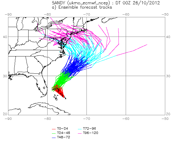
Figure 1: Example of multi-centre ensemble track predictions for hurricane Sandy.
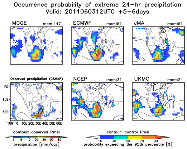
Figure 2: The forecast probability of heavy rainfall (exceeding the 95th percentile), based on four TIGGE ensembles, and a multi-centre grand ensemble.
|