Water: Improving water resource management through better understanding of the water cycle
CEOP-AEGIS: Towards an integrated water cycle monitoring system for Asia
Monitoring the water tower of Asia
Headwater of rivers that flow down to 1.4 billion people, the Tibetan Plateau, with an average altitude of 4,700 meters and an extent of 2.5 million square kilometres, plays a determinant role on both hydrology and climate of Southern and Eastern Asia. The dynamic and thermodynamic effects of the Plateau on the atmospheric circulation also influence downstream river flow. Surface topography and surface radiative and convective fluxes within the Atmospheric Boundary Layer not only determine the water balance of the Tibetan Plateau, but also exert a profound influence of the onset, maintenance and withdrawal of the Asian Monsoon. A good understanding of the linkage of land processes on the Plateau with monsoon onset and precipitation is of major relevance from both societal and environmental points of view for many Asian countries, in particular in terms of flood and drought, but also in terms of food security in a changing environment.
How can CEOP-AEGIS contribute to this problem?
Improving water management and predicting changes in water resources in Southeast Asia cannot rely on existing ground observation network only, whose spatial density could never be sufficient for such a challenge. Therefore, there is an urgent need for reliable, long-term observations from space. Observing systems on-board current and future satellites provide regular and global coverage of surface and atmospheric properties. Imaging spectro-radiometers, radars, microwave radiometers and backscatter LIDAR provide a very comprehensive suite of measurements over a wide range of wavelengths, time frequencies and spatial resolutions. The challenge is to devise new ways to merge efficiently every available observations rather than focusing on each instrument separately. Initiated in 2008, the CEOP-AEGIS project aims at building such a long-term observing system for the Tibetan Plateau to monitor surface bio-geophysical properties, energy and water balance, and to improve the modelling of the Asian monsoon and of extreme meteorological events.
“Efficiently merging every available observation can significantly improve our understanding of water processes, but also help to protect the population against extreme droughts and floods events.”
Specific Science and Technology components
Three main components are addressed:
- Observations of the terms of the water balance: precipitation, meltwater from snow and glaciers, changes in soil water content and evaporation for a period of three years are generated by integrating ground and satellite measurements on weekly and monthly basis. Radiative transfer models and algorithms are under development for different regions of the electro-magnetic spectrum.
- The water balance of the Plateau is calculated with a distributed hydrological model. Interactions of land surface hydrology with convective activity and the Asian Monsoon are being investigated by using a meso-scale atmospheric model.
- Time-series of image data are being used to demonstrate a Drought and a Flood Early Warning Systems.
|
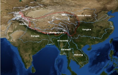
Figure 1: Major river basins of Asia.
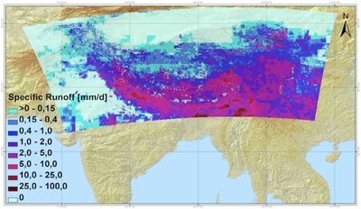
Figure 2: Specific runoff map for August 15th 2008.
|
A multi-disciplinary community of scientists and water management experts
With 18 European and Asia research organizations and Smalls to Medium Enterprises involving about a hundred participating scientists and experts, the CEOP-AEGIS project contributes to the creation of highly innovative datasets on the hydrology and climatology of the Tibetan plateau, but also to build up an active multi-disciplinary community. The expertise of investigators ranges from remote sensing experts to hydrologists, meteorologists, climatologists, geo-information engineers and water managers. Moreover, the project contributes to disseminate knowledge and technologies through a capacity building program, in collaboration with other scientific projects. More than 70 MSc and PhD students have been and are completing their education in the context of the project.
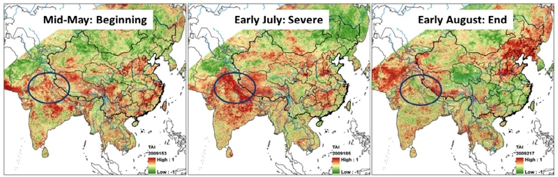
Figure 3: Drought event monitored during the summer 2009 using the Temperature Anomaly Index (Jia et al. 2011), with particular focus on the northern India drought.
Contributing to the GEOSS Water theme
By connecting disciplines to address the complexity of the water balance of the Tibetan plateau and of the Asian hydrological network, CEOP-AEGIS meets GEOSS’s motivations. Beside multi-disciplinarity and capacity building, this initiative also facilitates data sharing, promotes the GEO data sharing principles, and contributes to merge and sustain in-situ and space observations into harmonized, quality proof data standards. The new “CEOP-AEGIS Data Portal” designed within the project consists in a complete processing chain from the data producers to the end-users, to allow the access to project information, documentation and data catalogue. The available products range from in-situ to space-borne observations, but also meteorological and hydrological model outputs. Jointly hosted in France and China, this portal gives a concrete expression to CEOP-AEGIS’s objective to contribute to the Water theme of GEO.
“CEOP-AEGIS actively builds up a multi-disciplinary community focusing of Water in Asia and
contributes to facilitate, promote and sustain data sharing through a new data portal.”
Why GEOSS is necessary
The information on water resources is extracted from multiple space-borne observing systems: different “families” of sensors capture complementary signals, but the integration of data collected by each family requires the innovative effort promoted by GEOSS Virtual Constellations. Likewise the integration of space and ground measurements to produce trans-national information on water resources is not viable without GEOSS and the proactive initiatives of GEO.
Contact:
Prof. Massimo MENENTI
Coordinator of CEOP-AEGIS
Email: m.menenti@tudelft.nl
On the web: www.ceop-aegis.org
|
Faculty of Aerospace Engineering, Delft
University of Technology
Kluyverweg 1, 2629HS Delft
The Netherlands
|
Downloads:
eBrochure
Presentation.
|
|